![](/images/other/stat-length.png)
![Trail Equestrian La Bussière-sur-Ouche - Boucle La Bussiere - Photo](https://media.geolcdn.com/t/1900/400/ext.pjpeg?maxdim=2&url=https%3A%2F%2Fstatic1.geolcdn.com%2Fsiteimages%2Fupload%2Ffiles%2F1524743154cheval.jpg)
Boucle La Bussiere
magalizeller
User
![Length](/images/other/stat-length.png)
Length
8.6 km
![Max alt](https://static1.geolcdn.com/siteimages/upload/files/1508320355ic_sort_altitude_max_24dp.png)
Max alt
496 m
![Uphill gradient](https://static1.geolcdn.com/siteimages/upload/files/1508320355ic_sort_den_pos_24dp.png)
Uphill gradient
201 m
![Km-Effort](/images/other/stat-length.png)
Km-Effort
11.3 km
![Min alt](https://static1.geolcdn.com/siteimages/upload/files/1508320355ic_sort_altitude_min_24dp.png)
Min alt
309 m
![Downhill gradient](https://static1.geolcdn.com/siteimages/upload/files/1508320355ic_sort_den_neg_24dp.png)
Downhill gradient
202 m
![Boucle](https://static1.geolcdn.com/siteimages/upload/files/16400158638029165_repeat_loop_refresh_sync_direction_icon.png)
Boucle
Yes
Creation date :
2016-10-29 00:00:00.0
Updated on :
2016-10-29 00:00:00.0
![Equestrian](https://static1.geolcdn.com/sitytour/trail-icons/300.png)
1h11
Difficulty : Medium
![Scan this QR Code to open this trail in the SityTrail application](https://capi.geolives.com/qq0zvz2zws4bq2lad0pu/sitytour/trails/652697/qr.png?size=200)
FREE GPS app for hiking
About
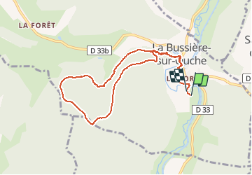
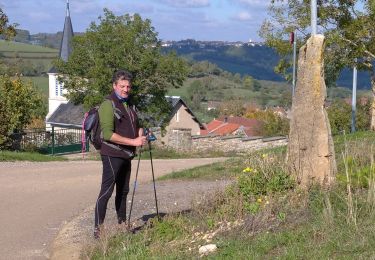
Trail Equestrian of 8.6 km to be discovered at Bourgogne-Franche-Comté, Côte-d'Or, La Bussière-sur-Ouche. This trail is proposed by magalizeller.
Description
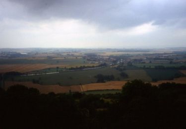
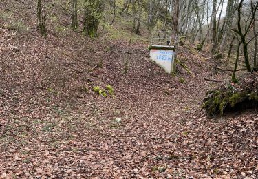
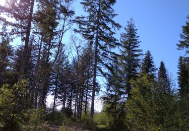
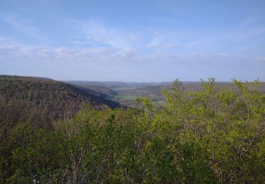
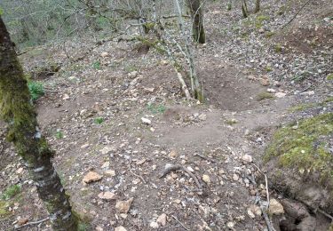
Belle balade dans la forêt, chemin en bon état dans trop de cailloux. Possibilité de raccourcir.
ça grimpe, mais pas trop violemment.
Positioning
Country:
France
Region :
Bourgogne-Franche-Comté
Department/Province :
Côte-d'Or
Municipality :
La Bussière-sur-Ouche
Location:
Unknown
Start:(Dec)
Start:(UTM)
630722 ; 5229803 (31T) N.
Comments
Trails nearby
![Trail Walking Barbirey-sur-Ouche - Le Tour de Barbiriacum - Barbirey sur Ouche - Photo](https://media.geolcdn.com/t/375/260/ext.jpg?maxdim=2&url=https%3A%2F%2Fservices.sitytrail.com%2FGeolivesWS%2FDownloadMedia.ashx%3FTrailID%3D104688%26Media%3D8091_1.jpg)
![Walking Walking](https://static1.geolcdn.com/sitytour/trail-icons/101.png)
Le Tour de Barbiriacum - Barbirey sur Ouche
Walking
Medium
(1)
Barbirey-sur-Ouche,
Bourgogne-Franche-Comté,
Côte-d'Or,
France
![](/images/other/stat-length.png)
10.5 km | 15.9 km-effort
2h 45min
![](https://static1.geolcdn.com/siteimages/upload/files/16400158638029165_repeat_loop_refresh_sync_direction_icon.png)
Yes
![Trail Walking La Bussière-sur-Ouche - La Bête de l'Auxois - La Bussière sur Ouche - Photo](https://media.geolcdn.com/t/375/260/ext.jpg?maxdim=2&url=https%3A%2F%2Fservices.sitytrail.com%2FGeolivesWS%2FDownloadMedia.ashx%3FTrailID%3D104674%26Media%3D8077_1.jpg)
![Walking Walking](https://static1.geolcdn.com/sitytour/trail-icons/101.png)
La Bête de l'Auxois - La Bussière sur Ouche
Walking
Difficult
(1)
La Bussière-sur-Ouche,
Bourgogne-Franche-Comté,
Côte-d'Or,
France
![](/images/other/stat-length.png)
25 km | 33 km-effort
6h 0min
![](https://static1.geolcdn.com/siteimages/upload/files/16400158638029165_repeat_loop_refresh_sync_direction_icon.png)
Yes
![Trail Walking La Bussière-sur-Ouche - Pierre du druide , grotte de tebsima - Photo](https://media.geolcdn.com/t/375/260/ext.jpg?maxdim=2&url=https%3A%2F%2Fmedia.geolcdn.com%2Ff%2Ff5fb0392-9ba6-4c1e-8853-76c9bb7fb3dc.jpg)
![Walking Walking](https://static1.geolcdn.com/sitytour/trail-icons/101.png)
Pierre du druide , grotte de tebsima
Walking
Medium
La Bussière-sur-Ouche,
Bourgogne-Franche-Comté,
Côte-d'Or,
France
![](/images/other/stat-length.png)
15.9 km | 23 km-effort
3h 32min
![](https://static1.geolcdn.com/siteimages/upload/files/16400158638029165_repeat_loop_refresh_sync_direction_icon.png)
Yes
![Trail Walking Antheuil - Saint JeandeBoeuf- Antheuil-Crugey-Labussièresur Ouche - Photo](https://media.geolcdn.com/t/375/260/ext.jpg?maxdim=2&url=https%3A%2F%2Fmedia.geolcdn.com%2Ff%2Fcfbbfa30-225e-4285-b48a-0a8696c4b14b.jpg)
![Walking Walking](https://static1.geolcdn.com/sitytour/trail-icons/101.png)
Saint JeandeBoeuf- Antheuil-Crugey-Labussièresur Ouche
Walking
Easy
Antheuil,
Bourgogne-Franche-Comté,
Côte-d'Or,
France
![](/images/other/stat-length.png)
27 km | 36 km-effort
8h 26min
![](https://static1.geolcdn.com/siteimages/upload/files/16400158638029165_repeat_loop_refresh_sync_direction_icon.png)
Yes
![Trail Walking Saint-Jean-de-Bœuf - Saint JeandeBoeuf-Gissey sur Ouche - Photo](https://media.geolcdn.com/t/375/260/ext.jpg?maxdim=2&url=https%3A%2F%2Fmedia.geolcdn.com%2Ff%2F8855f220-19b7-4cb5-9740-2586f5619cf3.jpg)
![Walking Walking](https://static1.geolcdn.com/sitytour/trail-icons/101.png)
Saint JeandeBoeuf-Gissey sur Ouche
Walking
Medium
Saint-Jean-de-Bœuf,
Bourgogne-Franche-Comté,
Côte-d'Or,
France
![](/images/other/stat-length.png)
22 km | 31 km-effort
8h 5min
![](https://static1.geolcdn.com/siteimages/upload/files/16400158638029165_repeat_loop_refresh_sync_direction_icon.png)
Yes
![Trail Walking Détain-et-Bruant - blockhaus de Saint-Jean de Boeuf - Photo](https://media.geolcdn.com/t/375/260/ext.jpg?maxdim=2&url=https%3A%2F%2Fmedia.geolcdn.com%2Ff%2F7b6e17cc-c96f-42ca-91f7-e764a111d3f2.jpg)
![Walking Walking](https://static1.geolcdn.com/sitytour/trail-icons/101.png)
blockhaus de Saint-Jean de Boeuf
Walking
Medium
Détain-et-Bruant,
Bourgogne-Franche-Comté,
Côte-d'Or,
France
![](/images/other/stat-length.png)
11 km | 13.5 km-effort
1h 41min
![](https://static1.geolcdn.com/siteimages/upload/files/16400158638029165_repeat_loop_refresh_sync_direction_icon.png)
Yes
![Trail Walking Barbirey-sur-Ouche - Tebzima - Photo](https://media.geolcdn.com/t/375/260/ext.jpg?maxdim=2&url=https%3A%2F%2Fservices.sitytrail.com%2FGeolivesWS%2FDownloadMedia.ashx%3FTrailID%3D1013095%26Media%3D20180730104607.jpg)
![Walking Walking](https://static1.geolcdn.com/sitytour/trail-icons/101.png)
Tebzima
Walking
Medium
Barbirey-sur-Ouche,
Bourgogne-Franche-Comté,
Côte-d'Or,
France
![](/images/other/stat-length.png)
13.4 km | 20 km-effort
4h 11min
![](https://static1.geolcdn.com/siteimages/upload/files/16400158638029165_repeat_loop_refresh_sync_direction_icon.png)
Yes
![Trail Walking La Bussière-sur-Ouche - St Victor canal - Photo](https://media.geolcdn.com/t/375/260/ext.jpg?maxdim=2&url=https%3A%2F%2Fmedia.geolcdn.com%2Ff%2F922cca4b-d8a7-4ae9-a8f6-94d903732d88.jpg)
![Walking Walking](https://static1.geolcdn.com/sitytour/trail-icons/101.png)
St Victor canal
Walking
Easy
La Bussière-sur-Ouche,
Bourgogne-Franche-Comté,
Côte-d'Or,
France
![](/images/other/stat-length.png)
12.8 km | 16.5 km-effort
2h 39min
![](https://static1.geolcdn.com/siteimages/upload/files/16400158638029165_repeat_loop_refresh_sync_direction_icon.png)
Yes
![Trail On foot Barbirey-sur-Ouche - barbirey - Photo](https://media.geolcdn.com/t/375/260/ext.jpg?maxdim=2&url=https%3A%2F%2Fmedia.geolcdn.com%2Ff%2Fd6bd1c62-1edb-4936-a48f-393652ec8299.jpg)
![On foot On foot](https://static1.geolcdn.com/sitytour/trail-icons/100.png)
barbirey
On foot
Medium
Barbirey-sur-Ouche,
Bourgogne-Franche-Comté,
Côte-d'Or,
France
![](/images/other/stat-length.png)
15.5 km | 23 km-effort
2min
![](https://static1.geolcdn.com/siteimages/upload/files/16400158638029165_repeat_loop_refresh_sync_direction_icon.png)
Yes